DOW-UAP-PR057a, "Spherical UAP in clouds"
Investigation reading
This Release 02 item is an official Department of War/DVIDS video record from WAR.GOV/PURSUE release row 116. The source label is DOW-UAP-PR057a, with the uploader-defined title “Spherical UAP in clouds.” Open Sky treats that wording as a source title, not as an analytical finding that the visible contrast features are spherical, anomalous, or physically identified.
The official Release 02 description says eight members of the U.S. House of Representatives requested access on March 6, 2026 to 51 potentially UAP-related records allegedly held by the Department of War and the Intelligence Community. AARO identified responsive materials on a classified network, and the release states that many of these materials lack a substantiated chain of custody. For this item specifically, AARO assesses that the video is likely derived from an infrared sensor aboard a U.S. military platform operating above the Yellow Sea in January 2023, and says a user uploaded it to a classified network in June 2024.
The DVIDS page and manifest also preserve a duplicate-record warning: AARO says this media is a duplicate of DOW-UAP-PR057b, alternately titled “[Platform] observes UAP in East China Sea 05 JAN 2023 INDOPACOM.” That is a provenance issue, not a resolved geography or date finding. This page records the PR057a row separately while flagging the shared DVIDS media pointer for later reconciliation.
What the released item appears to contain
The downloaded MP4 is a 70.97-second, 1920×1080 video with grayscale/infrared-looking sensor imagery. Sampled frames show clouds, haze, and later a darker textured surface that may be water or lower cloud/sea texture. The frames include a central reticle/crosshair, orange-red bracket-style overlay marks, a small N indicator, and black rectangular interface or masking blocks around parts of the frame.
The official DVIDS/WAR.GOV description breaks the visible sequence into these source-described intervals:
- 00:00–00:06 — described by the source as no content.
- 00:07–00:08 — an area of contrast enters from the left and exits near the center-right side of the frame.
- 00:09–00:20 — the sensor pans and cycles zoom levels multiple times.
- 00:21–00:31 — an area of contrast enters from the left and becomes indistinguishable against the background.
- 00:32–00:34 — the sensor zooms in and an area of contrast becomes distinguishable near the center.
- 00:35–00:52 — the sensor pans to track an area of contrast from left to right.
- 00:53–00:56 — the sensor zooms in and an area of contrast transits left to right in the bottom third of the frame.
- 00:57–01:10 — described by the source as no content.
The contact sheets support cautious source-review language only. A few sampled frames show tiny bright dash-like or point-like marks against cloud or haze backgrounds, especially around the short activity intervals near 8 seconds, mid-30s to early-50s seconds, and the lower-frame segment around 55 seconds. The same frames also contain clouds, haze, overlays, masking blocks, compression, downsampling, and sensor/display movement, so the still samples do not establish persistence, range, size, speed, identity, or anomalous behavior.
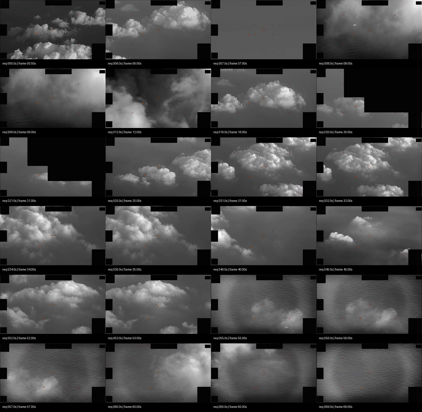
Derived contact sheet from the downloaded official MP4, sampled from 0.5 seconds through 69 seconds. Black gutters and timestamp labels are contact-sheet presentation elements; the reticle, orange-red marks, N indicator, and black rectangular mask/interface areas are visible within the released video frames.
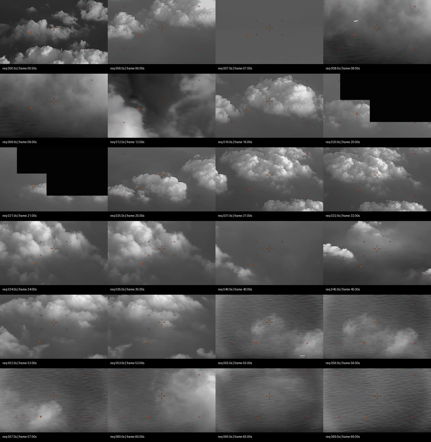
Center/lower crops from the same sampled frames. These crops make small contrast features easier to audit, but they are not a motion analysis and do not identify the feature or prove independent movement.
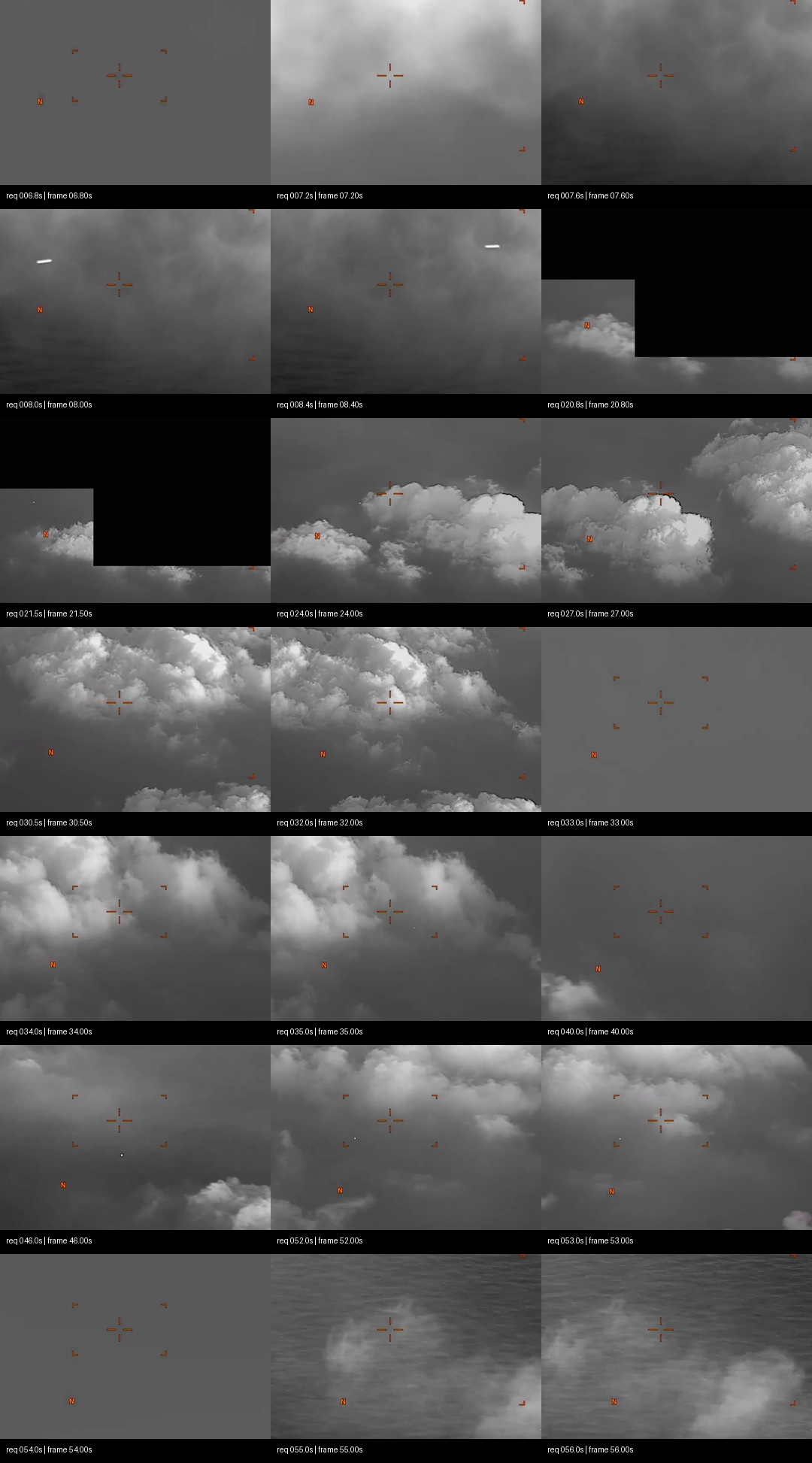
Cropped samples around the official activity windows. Several tiny bright marks are visible in isolated frames, but overlay graphics, cloud texture, masking, compression, and the still-frame sampling limit interpretation.
Source asset review
The DVIDS page resolved to https://www.dvidshub.net/video/1007720/dow-uap-pr057a-spherical-uap-clouds and exposed a direct official CloudFront MP4 URL for DOD_111719752.mp4. That individual media file was downloaded and inspected; the full Release 02 video ZIP was not downloaded as a substitute.
| Check | Observed value |
|---|---|
| Direct media URL | https://d34w7g4gy10iej.cloudfront.net/video/2605/DOD_111719752/DOD_111719752.mp4 |
| HTTP status / type | 200, binary/octet-stream |
| Content length / downloaded size | 32,245,123 bytes |
| Accept-ranges | bytes |
| Last-modified | Fri, 22 May 2026 11:30:34 GMT |
| ETag | "33ff95c783724c77dc10b240505c543c-4" |
| SHA-256 | 43d114fa153fa86523832e35bc9731883a67dd6bc9ea1d34c7afd5a83fe5e570 |
| Container | QuickTime/MP4 (mov,mp4,m4a,3gp,3g2,mj2) |
| Duration | 70.966667 seconds (00:01:10.97) |
| Video stream | H.264, 1920x1080, 30 fps, 2,129 decoded frames, yuv420p |
| Audio stream | AAC stereo, 48,000 Hz, about 70.921333 seconds |
| Audio signal check | Full decoded audio stream measured silent: RMS 0.0, max absolute sample 0.0 |
DVIDS page metadata observed during this pass: title DOW-UAP-PR057a, "Spherical UAP in clouds"; date taken 01.01.2023; date posted 05.22.2026 07:30; category B-Roll; video ID 1007720; VIRIN 230124-D-D0360-9336; filename DOD_111719752; length 00:01:10; location field AT SEA.
The source media duration and DVIDS length agree at approximately 1 minute 10 seconds. The audio track exists in the container but contains no measurable signal in this decode.
Source custody and provenance
Primary provenance for this page is the official WAR.GOV/PURSUE Release 02 manifest, the official DVIDS page, and the direct DVIDS/CloudFront MP4 exposed by that page.
The Release 02 video bundle inventory also contains a central-directory entry for this item: video_2605_DOD_111719752_DOD_111719752.mp4, size 32,239,151 bytes, CRC32 e415300a. The directly downloaded DVIDS MP4 is 32,245,123 bytes, which is 5,972 bytes larger than the ZIP-entry inventory size. That mismatch should be treated as a source-custody reconciliation lead, not as evidence that either copy is wrong.
Several catalog fields need to remain separated. The manifest incident date is 2023, and the manifest incident location is Yellow Sea. The DVIDS page lists date taken 01.01.2023, VIRIN 230124-D-D0360-9336, and location AT SEA. The official prose says AARO assesses the clip is likely from above the Yellow Sea in January 2023, while the duplicate-title note points to East China Sea 05 JAN 2023 INDOPACOM. Those are source labels and catalog facts; they do not resolve the exact event time, route, platform, or geolocation by themselves.
The duplicate PR057a/PR057b situation matters because the same DVIDS ID appears in two Release 02 manifest rows. Open Sky should preserve both row identities, then reconcile whether the duplicate title reflects one underlying media file, two classified-network upload records, or a later catalog normalization issue.
Graph context
The current Open Sky graph context did not return exact Release 02 graph nodes for this DVIDS ID, title, or selected slug. That absence is not a contradiction of the official release; it means this page is currently anchored to the official manifest and source media while Release 02 graph ingest catches up.
Any title-related or dataset-wide records should be treated as leads only. This page does not create a finding, hypothesis, or object classification from graph context.
Leads to check
- Reconcile
DOW-UAP-PR057aandDOW-UAP-PR057b: same DVIDS ID1007720, same direct MP4 pointer, but different uploader-defined titles and Yellow Sea/East China Sea wording. - Reconcile date fields before timeline use: manifest year
2023, DVIDS date taken01.01.2023, VIRIN prefix230124, and duplicate title05 JAN 2023should not be collapsed into one exact date without a source-custody note. - Compare the direct DVIDS MP4 with the Release 02 video ZIP entry, including whether the
5,972-byte difference reflects container metadata, transfer/versioning, or a distinct copy. - Seek platform, sensor, range, altitude, look angle, weather, cloud deck, sea-state, and aircraft/ship traffic context for the January 2023 Yellow Sea / East China Sea area before any prosaic or anomalous assessment.
- Test prosaic possibilities before escalation: cloud-edge contrast, water-surface glint or wake, bird/debris/balloon/drone/aircraft at unknown range, sensor/display artifact, compression artifact, masking/overlay artifact, and apparent motion induced by platform or sensor panning.
Limits
This is a source-review draft, not a conclusion. The official source itself warns that many Release 02 materials lack substantiated chain of custody. The public MP4 does not provide raw sensor data, calibrated telemetry, platform identification, exact geolocation, range, altitude, weather, traffic, or independent corroborating observations.
The contact sheets are derived from sampled frames and are included only to make the source review auditable. They show clouds, haze, possible water/sea texture, display overlays, black masking/interface blocks, and a few tiny bright contrast marks in selected frames. They do not prove identity, anomalous performance, physical size, distance, or source-event validity.
Graph coverage for this exact Release 02 asset is currently absent in the read-only context used for this page. Until graph ingest, source normalization, and cross-case links are added, graph-based aggregation should not be used as evidence for this item.
Sources
- WAR.GOV/PURSUE landing page: https://www.war.gov/UFO/
- Release 02 manifest row 116,
DOW-UAP-PR057a, release date5/22/26, agencyDepartment of War, kindVID, redactionTRUE, incident date2023, incident locationYellow Sea. - DVIDS video page: https://www.dvidshub.net/video/1007720
- DVIDS canonical page observed during source review: https://www.dvidshub.net/video/1007720/dow-uap-pr057a-spherical-uap-clouds
- Direct official MP4 exposed by DVIDS: https://d34w7g4gy10iej.cloudfront.net/video/2605/DOD_111719752/DOD_111719752.mp4
- Release 02 video ZIP bundle: https://d34w7g4gy10iej.cloudfront.net/uap052226.zip; bundle SHA-256
8200c60f179767f50f5e6d0bf8373dfef7220326728610241394bcb8de22272d; central-directory entryvideo_2605_DOD_111719752_DOD_111719752.mp4, CRC32e415300a.