DOW-UAP-PR063, "Spherical UAP [CALLSIGN] 2021/04/12 vid 2"
Investigation reading
This Release 02 item is official Department of War/PURSUE manifest row 123. The manifest title is DOW-UAP-PR063, "Spherical UAP [CALLSIGN] 2021/04/12 vid 2". Open Sky treats Spherical UAP, [CALLSIGN], and vid 2 as source/catalog wording, not as a conclusion about object identity, physical shape, origin, or anomalous performance.
The selected row points to DVIDS video ID 1007740. The DVIDS page currently resolves to https://www.dvidshub.net/video/1007740/dow-uap-pr063-spherical-uap-callsign-2021-04-12-vid-2, carries the same title as the manifest, and exposes a direct official MP4 for DOD_111719850.mp4.
The official release text says eight members of the U.S. House of Representatives requested access on March 6, 2026 to 51 potentially UAP-related records allegedly held by the Department of War and the Intelligence Community; AARO identified responsive materials on a classified network; and many of those materials lack a substantiated chain of custody. For this video, the source text says AARO assesses the clip is likely derived from a full-motion video camera and an infrared sensor aboard a U.S. military platform operating within the United States Central Command area of responsibility in 2021, and says a user uploaded it to a classified network in May 2024.
What the released item appears to contain
The downloaded MP4 is a 4 minute, 49.3 second, 1280×720 H.264 video. The visible presentation is consistent with a redacted sensor/display recording: black blocks cover several interface regions, cyan/teal reticle and display marks sit over the image, and the underlying scene changes from mottled arid-looking ground to rugged terrain, water/coastline-like dark areas in the early post-pan samples, and later ridged or eroded mountainous terrain. The public MP4 does not include readable platform identity, calibrated range, altitude, exact geolocation, target track data, or raw telemetry.
The official source description is limited and important: 00:00–00:49 — the sensor pans to track an area of contrast, keeping it generally within the center of the sensor field of view; 00:50 — the sensor pans away from the area of contrast. The first-minute samples are consistent with that description. Near the reticle in the early frames is a small, ambiguous area of contrast embedded in mottled terrain with nearby dirt tracks, washes, or pale linear ground features. Around 00:50, the view blurs or shifts as the sensor pans away, and later samples no longer show a clearly continuous center feature.
Sampled-frame review supports cautious language only. The contact sheets document a redacted sensor feed and changing terrain, but they do not show a distinct object that is continuously resolved through the full 4:49 sequence. Small bright or dark features appear intermittently in individual frames, yet they can be terrain texture, shadows, compression, sensor processing, display symbology, or momentary contrast effects. The sampled stills do not establish object identity, distance, physical size, independent motion, speed, altitude, or anomalous behavior.
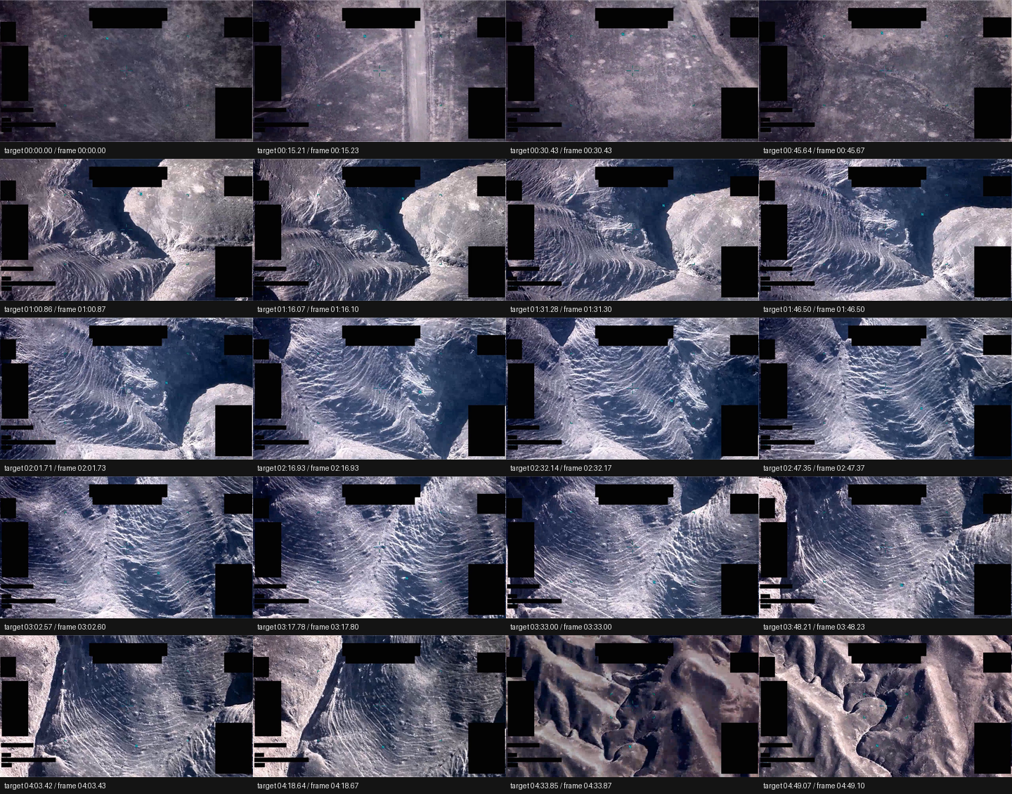
Derived full-frame contact sheet from the downloaded official MP4, sampled from 00:00 through 04:49. It shows redacted display regions, cyan/teal sensor symbology, changing terrain, and substantial scene movement. It is visual documentation of the released file, not object-identification analysis.
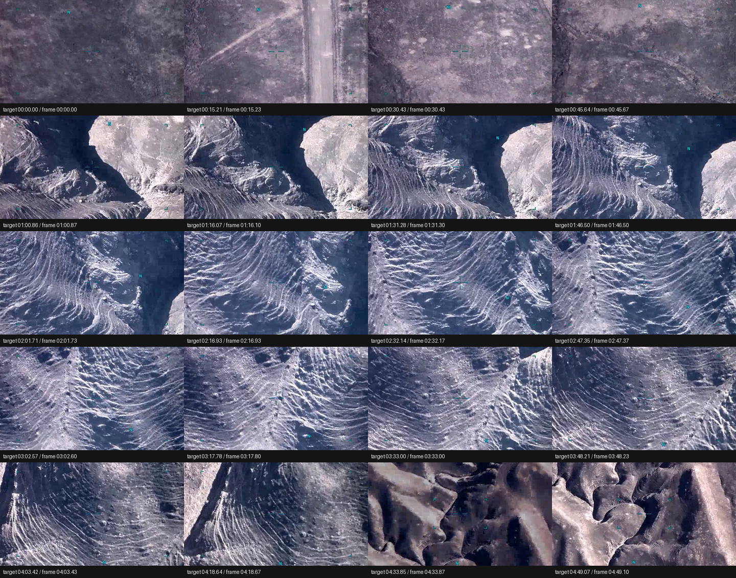
Derived center-crop samples from the same MP4. The crop emphasizes the reticle/overlay area. It shows changing ground and intermittent small contrast details, but not a clearly identifiable feature persisting through the full duration.
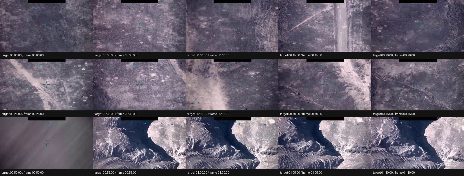
Derived first-minute center-crop samples around the official description's tracking interval and pan-away. The early frames show a small ambiguous contrast feature near the reticle within ordinary-looking terrain; the later frames show the sensor leaving that area. This sheet should be read with the limits of sampled stills, sensor motion, overlays, redaction, and compression in mind.
Source asset review
The selected manifest row uses DVIDS ID 1007740. The DVIDS request returned a redirect to https://www.dvidshub.net/video/1007740/dow-uap-pr063-spherical-uap-callsign-2021-04-12-vid-2, then returned 200 and exposed the direct official MP4 source shown below. The individual MP4 was downloaded and inspected directly; the full Release 02 video ZIP was not downloaded as a substitute.
| Check | Observed value |
|---|---|
| Selected manifest row | Release 02 row 123, DOW-UAP-PR063, release date 5/22/26 |
| DVIDS page requested | https://www.dvidshub.net/video/1007740 |
| DVIDS canonical page observed | https://www.dvidshub.net/video/1007740/dow-uap-pr063-spherical-uap-callsign-2021-04-12-vid-2 |
| Direct media URL | https://d34w7g4gy10iej.cloudfront.net/video/2605/DOD_111719850/DOD_111719850.mp4 |
| HTTP status / type | 200, video/mp4; byte-range probe returned 206 |
| Content length / downloaded size | 217,729,901 bytes |
| Accept-ranges | bytes |
| Last-modified | Thu, 21 May 2026 00:44:25 GMT |
| ETag | "1df18f6d48b579667450bd8d43545652-8" |
| SHA-256 | 4ab431378bcbf4c034e5c28154f07d5f9f0210126389434fad946838f00fdfa7 |
| CRC32 | bb98f287 |
| Container | QuickTime/MP4 (mov,mp4,m4a,3gp,3g2,mj2) |
| Duration | 289.266667 seconds (00:04:49.3) |
| Video stream | H.264, 1280x720, 30 fps, 8,678 frames, yuv420p |
| Audio stream | AAC stereo, 48,000 Hz, about 289.225333 seconds |
| Audio signal check | Full decoded audio stream measured silent: RMS 0.0, max absolute sample 0.0 |
DVIDS page metadata observed during source review: title DOW-UAP-PR063, "Spherical UAP [CALLSIGN] 2021/04/12 vid 2"; date taken 04.12.2021; date posted 05.22.2026 07:30; category B-Roll; video ID 1007740; VIRIN 210413-D-D0360-9905; filename DOD_111719850; length 00:04:49; location field (UNDISCLOSED LOCATION); courtesy source All Domain Anomaly Resolution Office.
The DVIDS length, MP4 stream duration, and official manifest duration align at approximately 4 minutes 49 seconds. The MP4 contains an AAC stereo audio stream, but the decoded stream measured as silent in this pass.
Source custody and provenance
Primary provenance for this page is the official WAR.GOV/PURSUE Release 02 manifest, the official DVIDS video page, and the direct DVIDS/CloudFront MP4 exposed by that page. The Release 02 video ZIP central-directory inventory lists video_2605_DOD_111719850_DOD_111719850.mp4, size 217,729,901 bytes, CRC32 bb98f287, stored without ZIP compression. Those size and CRC32 values match the directly downloaded DVIDS MP4 in this review. The ZIP bundle-level SHA-256 provided by the inventory context is 8200c60f179767f50f5e6d0bf8373dfef7220326728610241394bcb8de22272d.
The timing/location fields need careful separation. The manifest incident date is 2021, the DVIDS page lists date taken 04.12.2021, the VIRIN begins 210413, DVIDS posted the public page on 05.22.2026 07:30, and the source description says a user uploaded the video to a classified network in May 2024. Those fields should not be collapsed into an exact event time without additional chain-of-custody documentation. The manifest incident location is CENTCOM, while DVIDS lists (UNDISCLOSED LOCATION).
The official description is expressly informational and says readers should not interpret any part of it as an analytical judgment, investigative conclusion, or factual determination regarding the described event's validity, nature, or significance. Open Sky preserves that caution here.
Graph context
The read-only graph context for this run did not return exact Release 02 graph nodes for this selected slug, DVIDS ID, or title. That absence is not a contradiction of the official release; it means this page is currently anchored to the official manifest, DVIDS page, and downloaded source media while Release 02 graph ingest catches up.
Any title-related, dataset-wide, or older graph records should be treated as leads only. This page does not create a finding, object classification, or anomaly claim from graph context.
Leads to check
- Preserve the source-language distinction between the uploader-defined title (
Spherical UAP [CALLSIGN] 2021/04/12 vid 2) and any later analytical wording. The title is not a shape finding. - Reconcile the timing fields before timeline use: manifest incident date
2021, DVIDS date taken04.12.2021, VIRIN prefix210413, DVIDS posting time05.22.2026 07:30, and the source statement that a user uploaded the video in May 2024. - Reconcile geography before map use: manifest location
CENTCOM, DVIDS location(UNDISCLOSED LOCATION), and source wording about a U.S. military platform within the United States Central Command area of responsibility. - Compare this item cautiously with adjacent manifest rows in the same uploader-title/date family, including
DOW-UAP-PR061,DOW-UAP-PR062, and any laterSpherical UAP [CALLSIGN] 2021/04/12entries, after their individual source files and custody fields are reviewed. - If a raw or less-compressed source export becomes available, review the full 00:00–00:49 tracking interval and the 00:50 pan-away with platform motion, sensor mode, line of sight, range, altitude, stabilization, and surrounding terrain or atmospheric context.
- Test prosaic and presentation possibilities before escalation: terrain texture, roads/tracks/washes, coastline or water/terrain contrast, shadows, parallax from platform movement, sensor pan, zoom/focus/exposure changes, tracking-box behavior, stabilization effects, display overlays, masking/redaction, compression artifacts, sensor gain/contrast changes, glare/glint, birds/debris/balloons/drones/aircraft at unknown range, and apparent motion induced by platform or sensor movement.
Limits
This is a source-review draft, not a conclusion. The official release itself warns that many Release 02 materials lack substantiated chain of custody. The public MP4 does not include raw sensor data, calibrated telemetry, platform identification, exact geolocation, range, altitude, weather, traffic data, or independent corroborating observations.
The contact sheets are derived from sampled frames and are included only to make the source review auditable. They show redacted sensor/display overlays, black masks, changing terrain, a small ambiguous early contrast feature near the reticle, and the 00:50 pan-away. They do not prove identity, anomalous performance, physical size, distance, speed, or source-event validity.
Graph coverage for this exact Release 02 asset is currently absent in the read-only context used for this page. Until graph ingest, source normalization, and cross-case links are added, graph-based aggregation should not be used as evidence for this item.
Sources
- WAR.GOV/PURSUE landing page: https://www.war.gov/UFO/
- Release 02 manifest row 123,
DOW-UAP-PR063, release date5/22/26, agencyDepartment of War, kindVID, redactionTRUE, incident date2021, incident locationCENTCOM. - DVIDS video page: https://www.dvidshub.net/video/1007740
- DVIDS canonical page observed during source review: https://www.dvidshub.net/video/1007740/dow-uap-pr063-spherical-uap-callsign-2021-04-12-vid-2
- Direct official MP4 exposed by DVIDS: https://d34w7g4gy10iej.cloudfront.net/video/2605/DOD_111719850/DOD_111719850.mp4
- Release 02 video ZIP bundle: https://d34w7g4gy10iej.cloudfront.net/uap052226.zip; bundle SHA-256
8200c60f179767f50f5e6d0bf8373dfef7220326728610241394bcb8de22272d; central-directory entryvideo_2605_DOD_111719850_DOD_111719850.mp4, size217,729,901bytes, CRC32bb98f287.