DOW-UAP-PR069, "F/A-18 FLIR UAP"
Investigation reading
This Release 02 item is an official Department of War / AARO video record from manifest row 129, published in the 5/22/26 WAR.GOV/PURSUE release and mirrored through DVIDS video ID 1007781. The uploader-defined title is F/A-18 FLIR UAP. That title is source/catalog language; it should not be treated by itself as proof of platform identity, object identity, range, speed, or anomalous performance.
The official description says eight U.S. House members requested access to 51 potentially UAP-related records allegedly held by the Department of War and the Intelligence Community. AARO identified responsive materials held on a classified network and warns that many of these materials lack a substantiated chain of custody. For this row, AARO assesses that the video is likely derived from an infrared sensor aboard a U.S. military platform operating within the United States Northern Command area of responsibility in 2022, and says a user uploaded it to a classified network in July 2023.
The manifest lists incident date as Not stated and incident location as NORTHCOM. The DVIDS page lists date taken 01.01.2022, VIRIN 220101-D-D0360-7009, filename DOD_111720700, location (UNDISCLOSED LOCATION), and length 00:00:29. Those fields are useful provenance, but they do not by themselves resolve the original event time, platform, sensor model, or chain of custody.
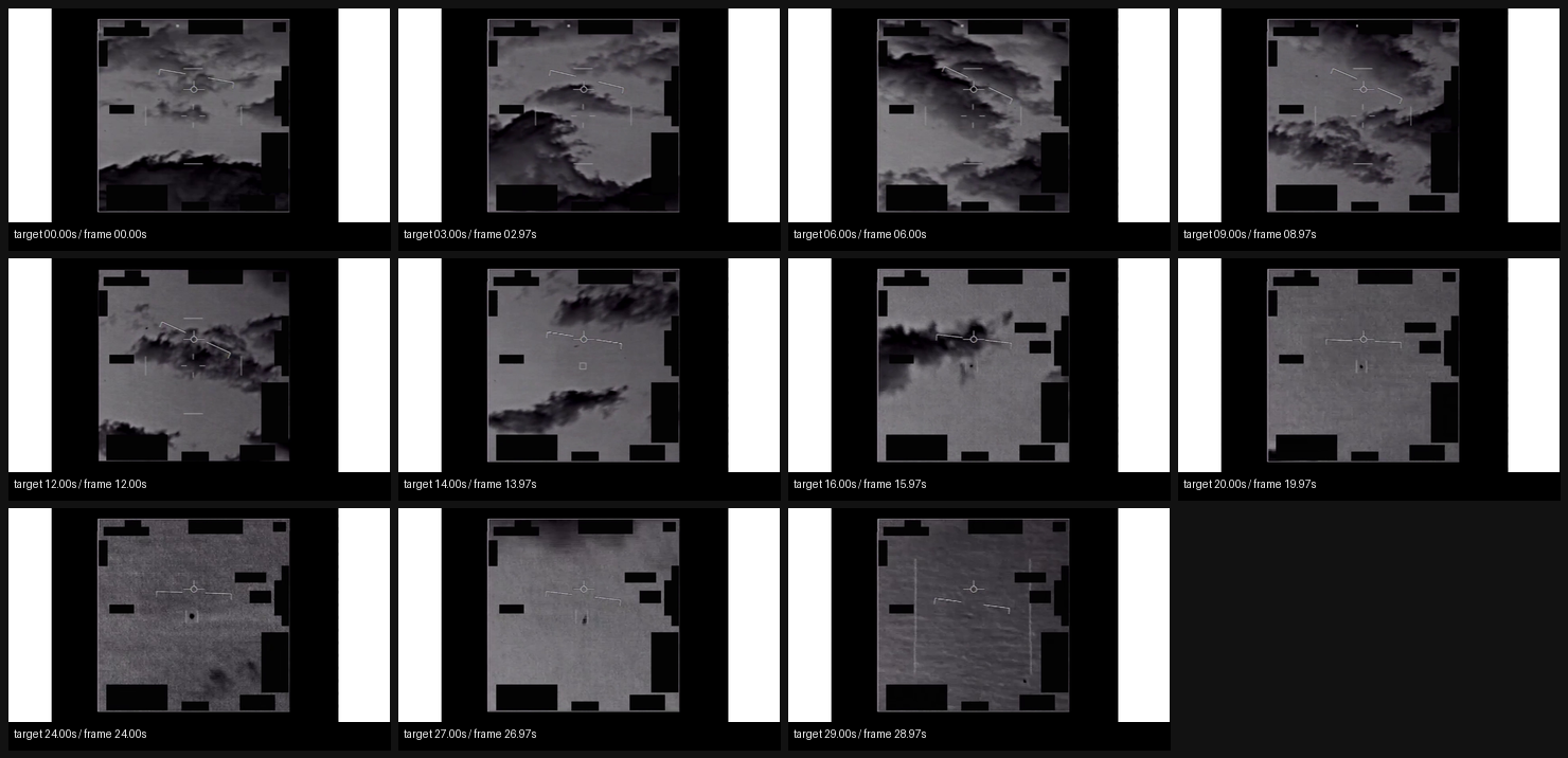
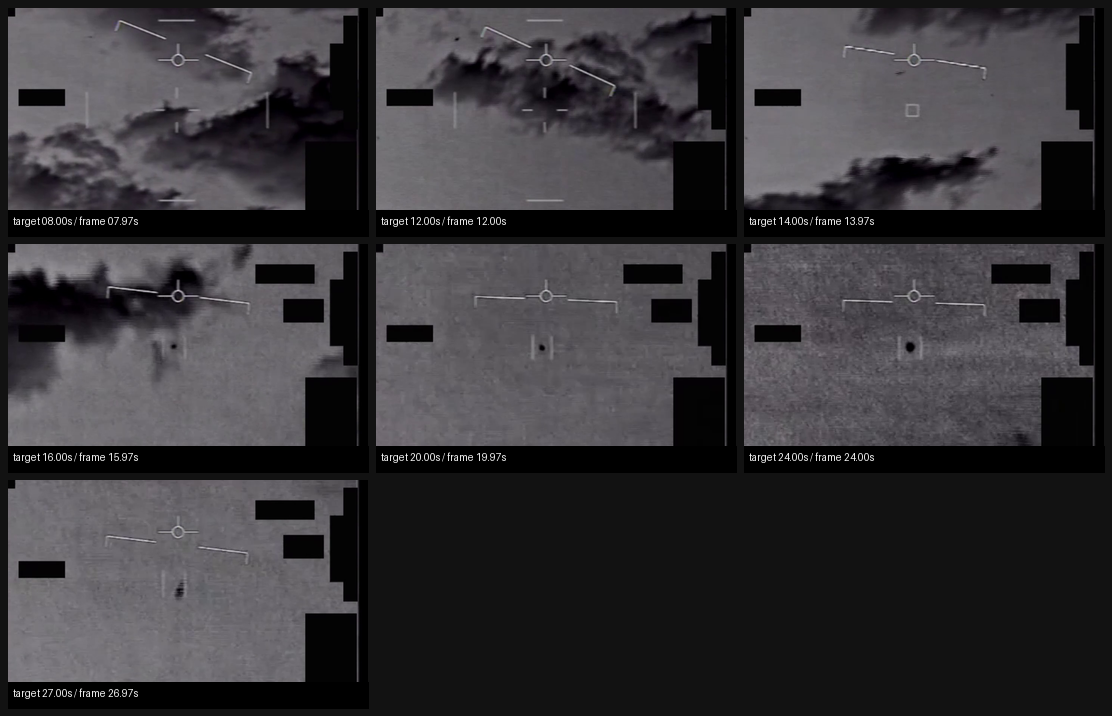
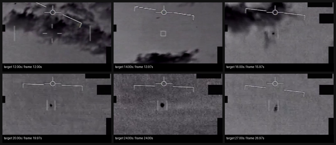
The source description identifies a single visual sequence: a sensor pans to track an area of contrast; at the 14-second mark, a reticle surrounds the area of contrast; at the 27-second mark, the reticle loses its track on the area of contrast. The release itself says this description is informational only and should not be read as an analytical judgment, investigative conclusion, or factual determination.
What the released item appears to contain
The downloaded direct MP4 appears to show a grayscale / infrared-looking sensor-display view with a central reticle and repeated black display-edge masks or blocks around the frame. The sampled frames show broad darker textured regions in the earlier part of the clip and a more uniform gray, grainy background in later samples.
In the center and tight-reticle crops, a compact dark contrast feature is intermittently visible near the reticle region, clearest in the later samples around 00:20, 00:24, and 00:27. Around 00:14, the reticle overlay is visibly present around the relevant area; by 00:27, the contrast feature appears offset below the reticle/overlay relationship in the sampled crop, consistent with the source statement that the reticle loses track. The public MP4 does not provide enough context to infer physical shape, size, range, speed, altitude, aircraft identity, or cause.
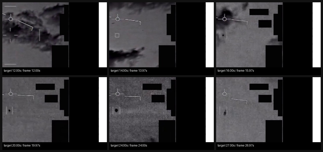
The right-center crop mostly shows display edge/masking and reticle fragments, with little additional scene context. The contact sheets below are derived review aids from the downloaded public MP4, not independent evidence.
Source asset review
The individual official DVIDS/CloudFront MP4 was downloaded and inspected directly; the full Release 02 video ZIP was not used as a substitute. The direct media response returned 200, content-type: binary/octet-stream, accept-ranges: bytes, content-length: 14735885, last-modified: Fri, 22 May 2026 11:31:08 GMT, and ETag "cbd35e5d90f4d9d51eefe0a70c079875-2". A byte-range probe returned 206 with content-range: bytes 0-0/14735885.
| Field | Source-review value |
|---|---|
| Direct media URL | https://d34w7g4gy10iej.cloudfront.net/video/2605/DOD_111720700/DOD_111720700.mp4 |
| Downloaded size | 14,735,885 bytes |
| SHA-256 | 7e81fd782a5b98af5cb941b6e5cce865f15324dea41b8c4cf4577f3d02c3fd66 |
| CRC32 of downloaded direct MP4 | 18f2acbb |
| Container | QuickTime / MP4 |
| Duration | 29.766667 seconds |
| Video stream | H.264, 1920x1080, 30 fps, 893 frames, yuv420p |
| Audio stream | AAC stereo, 48,000 Hz, about 29.726667 seconds |
| Audio signal check | decoded audio RMS 0.0, max absolute sample 0.0; effectively silent in this review |
| DVIDS filename / VIRIN | DOD_111720700 / 220101-D-D0360-7009 |
| DVIDS listed length | 00:00:29 |
The Release 02 remote video-ZIP central directory lists video_2605_DOD_111720700_DOD_111720700.mp4 as 14,730,830 bytes with CRC32 eb65aae5, stored uncompressed. That does not match the downloaded direct DVIDS MP4 size or CRC32. Until the ZIP entry is byte-compared against the direct DVIDS object, this should be treated as a source-custody/versioning lead, not as a substantive finding about the imagery.
Source custody and provenance
Primary public provenance for this page is the official WAR.GOV/PURSUE Release 02 landing page, the Release 02 manifest row, and the DVIDS page for video 1007781. The DVIDS page resolves to https://www.dvidshub.net/video/1007781/dow-uap-pr069-f-18-flir-uap, with title DOW-UAP-PR069, "F/A-18 FLIR UAP", category B-Roll, date taken 01.01.2022, date posted 05.22.2026 07:31, location (UNDISCLOSED LOCATION), filename DOD_111720700, VIRIN 220101-D-D0360-7009, listed length 00:00:29, and courtesy source All Domain Anomaly Resolution Office.
The custody story is intentionally bounded. The public release says many responsive materials lack a substantiated chain of custody; the title says F/A-18 FLIR UAP, while the body description more generally says AARO assesses the video is likely derived from an infrared sensor aboard a U.S. military platform in NORTHCOM in 2022. This page preserves those source claims without converting them into findings about the platform, sensor, target, or event validity.
Graph context
No exact Release 02 graph record was returned for this slug, title, or DVIDS ID during this run's read-only graph context check. That is not a source-access problem; it means this page is currently anchored to official manifest/DVIDS provenance while graph ingest for Release 02 catches up. Future title-related or dataset-wide graph hits should be treated as leads until their provenance links resolve back to this exact official asset.
Leads to check
- Reconcile the manifest
Not statedincident date, AARO's2022/NORTHCOMwording, the DVIDS01.01.2022date-taken field, and VIRIN220101-D-D0360-7009before asserting a precise event date. - Byte-compare the direct DVIDS MP4 against the Release 02 video-ZIP entry because the direct-file size/CRC32 and ZIP central-directory size/CRC32 do not match.
- Review the
00:14reticle-surround and00:27track-loss moments at original resolution with frame-by-frame stepping, stabilized coordinate tracking, and clear separation of display overlays from scene content. - Seek original sensor/custody metadata if available: platform, sensor model, field of view, zoom state, line of sight, range, track files, timestamps, and any aircraft or air-defense context.
- Run prosaic checks before escalation if time/location can be narrowed: aircraft/air traffic, celestial and atmospheric sources, balloons or debris, birds, sensor/display artifacts, compression effects, and platform-motion artifacts.
Limits
This is a compressed, redacted public MP4 with no released platform telemetry, range, altitude, azimuth, sensor model, field of view, original sensor file, track file, or independent corroborating sensor record on this page. The reticle, black masks, low-resolution contact sheets, silent audio track, and chain-of-custody warning limit interpretation. The contact sheets are useful for source review, but they are not a substitute for full-motion sensor analysis. This page is a source-review draft and not a finding.
Sources
- WAR.GOV/PURSUE Release 02 landing page: https://www.war.gov/UFO/
- DVIDS video page: https://www.dvidshub.net/video/1007781
- DVIDS direct media asset: https://d34w7g4gy10iej.cloudfront.net/video/2605/DOD_111720700/DOD_111720700.mp4
- Release 02 document bundle: https://www.war.gov/medialink/ufo/052226/release_02/release_02_document_bundle.zip
- Release 02 video bundle: https://d34w7g4gy10iej.cloudfront.net/uap052226.zip
- Official Release 02 manifest row 129,
DOW-UAP-PR069, "F/A-18 FLIR UAP", release date5/22/26, agencyDepartment of War, kindVID.