DOW-UAP-PR076, "03 January 2021 [CALLSIGN] (Mission) observes UAP"
Investigation reading
This Release 02 item is an official Department of War / AARO video record from manifest row 136, published in the 5/22/26 WAR.GOV/PURSUE release and mirrored through DVIDS video ID 1007804. The public title is preserved as source/catalog language: "03 January 2021 [CALLSIGN] (Mission) observes UAP". The callsign is redacted in the public title, and this page does not infer the aircraft, unit, crew, or mission identity behind that redaction.
The official release description says eight U.S. House members requested access to 51 potentially UAP-related records allegedly held by the Department of War and the Intelligence Community. AARO identified responsive materials held on a classified network and warns that many of these materials lack a substantiated chain of custody. For this row, AARO assesses that the public video is likely derived from an infrared sensor aboard a U.S. military platform operating within the United States Central Command area of responsibility in January 2021, and says a user uploaded the video to a classified network in January 2021.
The source-provided video description lists a duration of 00:04:57. It describes 00:00 to 01:51 as No content; says that from 01:52 to 02:48 an area of contrast becomes visible near the center of the top half of the frame while the sensor pans to keep it generally near the center of the field of view; says that from 02:49 to 02:55 the sensor zooms in and the area of contrast exits the frame in the bottom-left of the display; and describes 02:55 to 04:57 as No content. The same description is explicitly informational only and should not be interpreted as an analytical judgment, investigative conclusion, or factual determination about the described event's validity, nature, or significance.
The DVIDS page resolves to a canonical page for video 1007804 and lists category B-Roll, date taken 01.03.2021, date posted 05.22.2026 07:30, location (UNDISCLOSED LOCATION), filename DOD_111720857, VIRIN 210103-D-D0360-5870, and length 00:04:57.
What the released item appears to contain
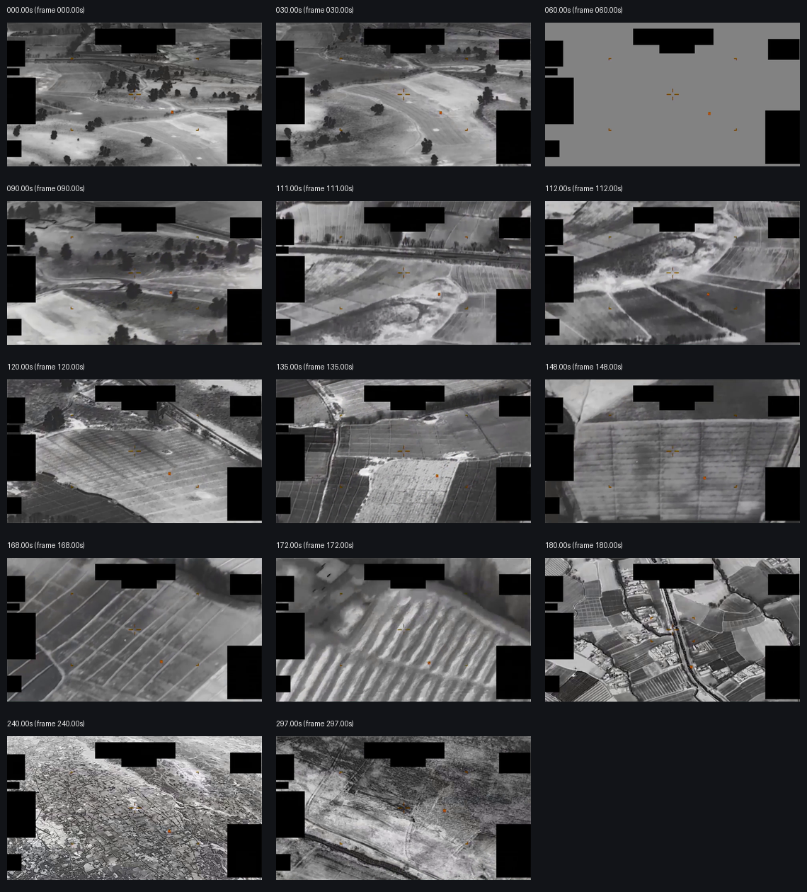
The downloaded direct MP4 is a 1280×720 sensor-display clip with grayscale imagery, a central reticle/crosshair, small orange display marks, and repeated black masking or redaction blocks around parts of the display. The public source says the imagery is likely infrared; this page treats that as source language, not as an independent Open Sky sensor determination.
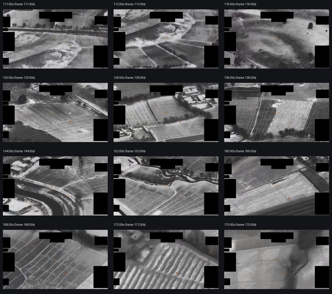
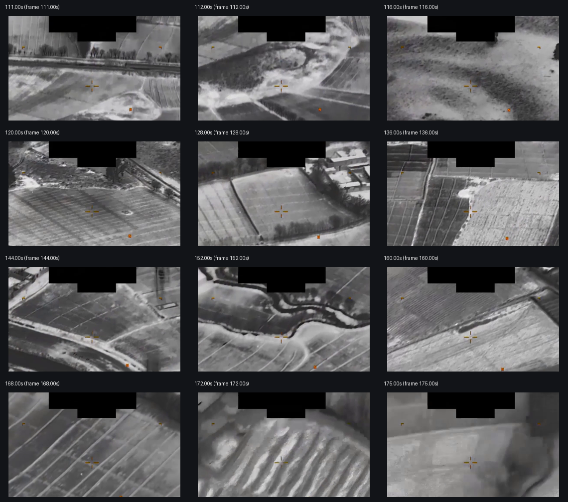
Sampled frames show an elevated sensor view over rural or agricultural terrain: field boundaries, roads or tracks, tree lines, drainage/hedgerow features, and scattered built-up areas. The source's No content labels do not mean every frame is visually blank; in this public MP4, those intervals can still show background terrain and overlays. In this page, No content is preserved as the release's own event-content label, not converted into an Open Sky finding.
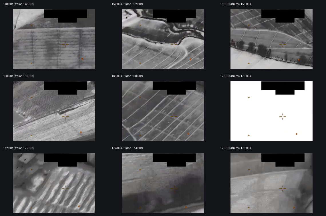
During the source-described event window, the contact sheets show the sensor panning across fields and terrain. A small contrast point or patch is intermittently visible near the central/upper-center field of view in some sampled frames, especially around the later portion of the described tracking window, but it is not resolved well enough in still samples to identify. The sensor/display also changes framing during the 02:49 to 02:55 zoom interval; one sampled frame around 170 seconds is washed out, and later sampled frames become harder to interpret as the view zooms/reframes. The official description says the area of contrast exits the display at the bottom-left; the still contact sheets alone are not enough to independently reconstruct that path.
A dark, plume-like or terrain-contrast region appears on the right side of one sampled late frame, but it cannot be tied with confidence to the source-described tracked contrast feature from these still samples alone. The visible review therefore stays at the level of source-backed description: a public sensor-display clip with a source-described area of contrast, panning/tracking, zoom/reframing, and loss/exit from the frame. It does not establish object identity, range, altitude, speed, size, anomalous performance, or platform identity.
The MP4 includes an AAC stereo audio stream, but a full decoded audio check returned zero signal in this run (RMS 0.0, mean absolute sample 0.0, max absolute sample 0.0). No transcript or audible content is quoted here. The contact sheets below are derived review aids from the downloaded official MP4; they are not independent evidence and should not be used to infer cause or identity.
Source asset review
The individual official DVIDS/CloudFront MP4 was downloaded and inspected directly; the full Release 02 video ZIP was not used as a substitute. The direct media response returned 200, content-type: binary/octet-stream, accept-ranges: bytes, content-length: 85356068, last-modified: Fri, 22 May 2026 11:30:52 GMT, and ETag "2f691888cfe29d36c518886565a77001-11". A byte-range probe returned 206 with content-range: bytes 0-0/85356068.
| Field | Source-review value |
|---|---|
| Direct media URL | https://d34w7g4gy10iej.cloudfront.net/video/2605/DOD_111720857/DOD_111720857.mp4 |
| Downloaded size | 85,356,068 bytes |
| SHA-256 | de46a047b742c12692c28cd084569a793f2272ab450b47604043cc8ee3d7e901 |
| CRC32 of downloaded direct MP4 | 9c5bedee |
| Container | QuickTime / MOV (mov,mp4,m4a,3gp,3g2,mj2) |
| Duration | 297.366667 seconds (00:04:57 rounded) |
| Bit rate | 2,296,318 bps |
| Video stream | H.264, 1280x720, 30 fps, 8,921 frames, yuv420p |
| Audio stream | AAC stereo, 48,000 Hz, about 297.332 seconds, 13,939 stream frames |
| Audio signal check | 13,938 decoded audio frames / 28,543,872 sample values; RMS 0.0, mean absolute sample 0.0, max absolute sample 0.0; audio stream present but effectively silent in this decode |
| DVIDS filename / VIRIN | DOD_111720857 / 210103-D-D0360-5870 |
| DVIDS listed length | 00:04:57 |
The Release 02 remote video-ZIP central directory lists video_2605_DOD_111720857_DOD_111720857.mp4 as 85,350,745 bytes with CRC32 e273e279, stored uncompressed. That does not match the downloaded direct DVIDS MP4 size or CRC32. Until the ZIP entry is byte-compared against the direct DVIDS object, this should be treated as a source-custody/versioning lead, not as a substantive finding about the imagery.
Source custody and provenance
Primary public provenance for this page is the official WAR.GOV/PURSUE Release 02 landing page, the Release 02 manifest row, and the DVIDS page for video 1007804. The public DVIDS page resolves to https://www.dvidshub.net/video/1007804/dow-uap-pr076-03-january-2021-callsign-mission-observes-uap and exposes the direct media asset at https://d34w7g4gy10iej.cloudfront.net/video/2605/DOD_111720857/DOD_111720857.mp4.
The custody posture is intentionally bounded. The public release says many responsive materials lack a substantiated chain of custody. This row says the video was uploaded to a classified network in January 2021 and is likely derived from an infrared sensor aboard a U.S. military platform operating within the CENTCOM area of responsibility in January 2021. DVIDS adds a 01.03.2021 date taken, (UNDISCLOSED LOCATION) location, and VIRIN 210103-D-D0360-5870. Those fields are compatible at the broad catalog level, but they still need original sensor/platform records before Open Sky can assert precise platform identity, range, target identity, coordinates, or event reconstruction. This page preserves the official manifest/DVIDS provenance and the downloaded-source inspection facts without converting the title, visible contrast region, or AARO summary into an Open Sky finding.
Graph context
No exact Release 02 graph record was returned for this slug, title, or DVIDS ID during this run's read-only graph context check. That is not a source-access problem; it means this page is currently anchored to official manifest/DVIDS provenance while graph ingest for Release 02 catches up. Future title-related or dataset-wide graph hits should be treated as leads until their provenance links resolve back to this exact official asset.
Leads to check
- Reconcile the manifest's
CENTCOMlocation, the DVIDS(UNDISCLOSED LOCATION)field, the01.03.2021DVIDS date taken, the210103-D-D0360-5870VIRIN, and the source statement that a user uploaded the video to a classified network in January 2021 before asserting a precise mission or platform reconstruction. - Byte-compare the direct DVIDS MP4 against the Release 02 video-ZIP entry because the direct-file size/CRC32 and ZIP central-directory size/CRC32 do not match.
- Review the
01:52to02:55sequence in full motion before treating any small contrast point, terrain feature, or late-frame dark region as a discrete physical object; still samples cannot resolve sensor tracking, platform motion, background terrain, compression, redaction, zoom behavior, or display artifacts. - Identify the sensor/display mode, zoom state, reticle meaning, masking/redaction effects, platform position, line of sight, range, and exact recording context.
- Run prosaic context checks before escalation: aircraft, drones, balloons, birds, debris, ordinary thermal targets, ground vehicles or ground heat sources, smoke/dust/terrain contrast, clouds or atmospheric effects, sensor contrast/auto-gain behavior, parallax from platform motion, display/redaction artifacts, CENTCOM-area air/ground activity, weather, and any available military or civilian incident logs for January 2021.
Limits
This is a compressed public MP4 derived from a classified-network upload, and the release-level source warning says many responsive materials lack a substantiated chain of custody. The public record does not provide the original file hash, original sensor metadata, platform identity, precise recording time beyond catalog date, line of sight, range, altitude, coordinates, independent radar or optical tracks, air/ground traffic correlation, weather correlation, or original witness/operator notes on this page. A source-described area of contrast is intermittently visible in sampled public frames during the event window, and the sensor/display zooms or reframes before the feature is no longer trackable from the public samples, but its source, cause, distance, scale, and event significance remain unresolved from this asset alone. This page is a source-review draft and not a finding.
Sources
- WAR.GOV/PURSUE Release 02 landing page: https://www.war.gov/UFO/
- DVIDS video page: https://www.dvidshub.net/video/1007804
- DVIDS direct media asset: https://d34w7g4gy10iej.cloudfront.net/video/2605/DOD_111720857/DOD_111720857.mp4
- Release 02 document bundle: https://www.war.gov/medialink/ufo/052226/release_02/release_02_document_bundle.zip
- Release 02 video bundle: https://d34w7g4gy10iej.cloudfront.net/uap052226.zip
- Official Release 02 manifest row 136,
DOW-UAP-PR076, "03 January 2021 [CALLSIGN] (Mission) observes UAP", release date5/22/26, agencyDepartment of War, kindVID.