DOW-UAP-PR086, "UAP from Dec 2019 (East Coast)"
Investigation reading
This Release 02 item is an official Department of War / AARO video record from manifest row 146, published in the 5/22/26 WAR.GOV/PURSUE release and mirrored through DVIDS video ID 1007797. The public title is preserved as catalog language: "UAP from Dec 2019 (East Coast)". This page does not infer the platform, operator, mission, precise coastal location, or identity of the tracked contrast feature from the title.
The official release description says eight U.S. House members requested access to 51 potentially UAP-related records allegedly held by the Department of War and the Intelligence Community. AARO identified responsive materials held on a classified network and warns that many of these materials lack a substantiated chain of custody. For this row, AARO assesses that the public video is likely derived from an infrared sensor aboard a U.S. military platform operating within the United States Northern Command area of responsibility in 2019, and says a user uploaded the video to a classified network in September 2020.
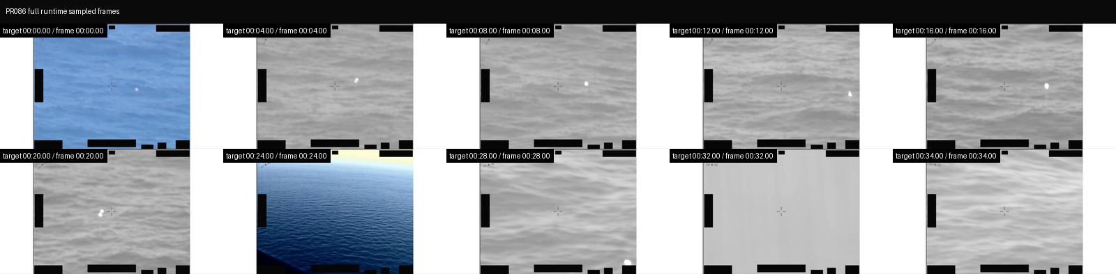
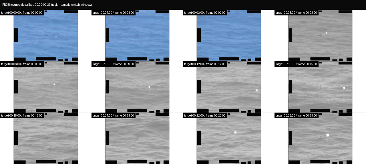
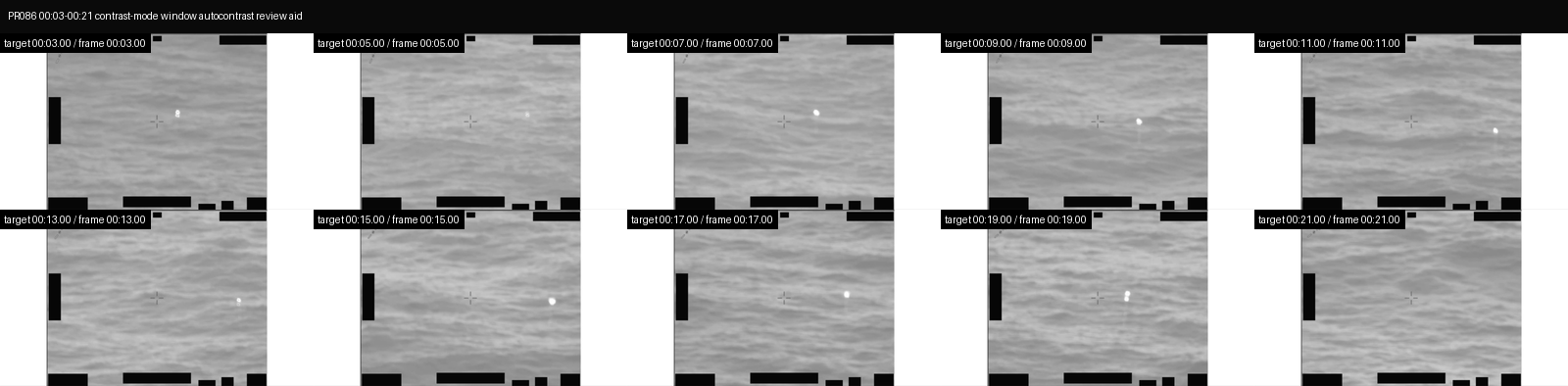
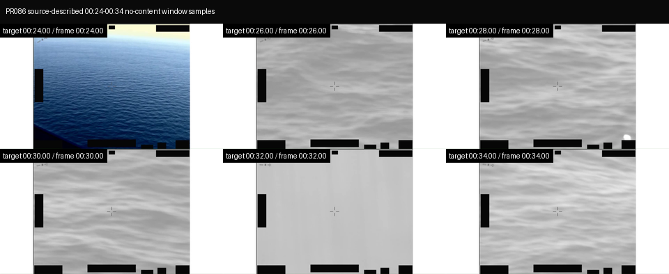
The source-provided video description lists a duration of 00:00:34 and breaks the public clip into four windows: 00:00 to 00:02, the sensor pans to track an area of contrast; 00:03 to 00:21, the sensor switches contrast modes while tracking an area of contrast; 00:22 to 00:23, the sensor pans to track an area of contrast; and 00:24 to 00:34, No content. The same source text is explicitly informational only and should not be interpreted as an analytical judgment, investigative conclusion, or factual determination about the described event's validity, nature, or significance.
The DVIDS page resolves to a canonical page for video 1007797 and lists country/display location UNITED STATES / US, date taken 12.01.2019, date posted 05.22.2026 07:30, category B-Roll, credit Courtesy Video, unit All Domain Anomaly Resolution Office, filename DOD_111720827, VIRIN 191201-D-D0360-9934, and length 00:00:34. The DVIDS length, manifest/source description, and downloaded MP4 duration are aligned at about thirty-four seconds.
What the released item appears to contain
The downloaded direct MP4 is a 1920×1080 short sensor-display clip. Sampled frames show water or ocean-surface texture, fixed reticle/crosshair marks near the center, black display/UI or masking elements along frame edges and the lower border, and a mixture of color and monochrome/infrared-like display modes. The public source says the video is likely derived from an infrared sensor; this page treats that as source language, not as an independent Open Sky sensor determination.
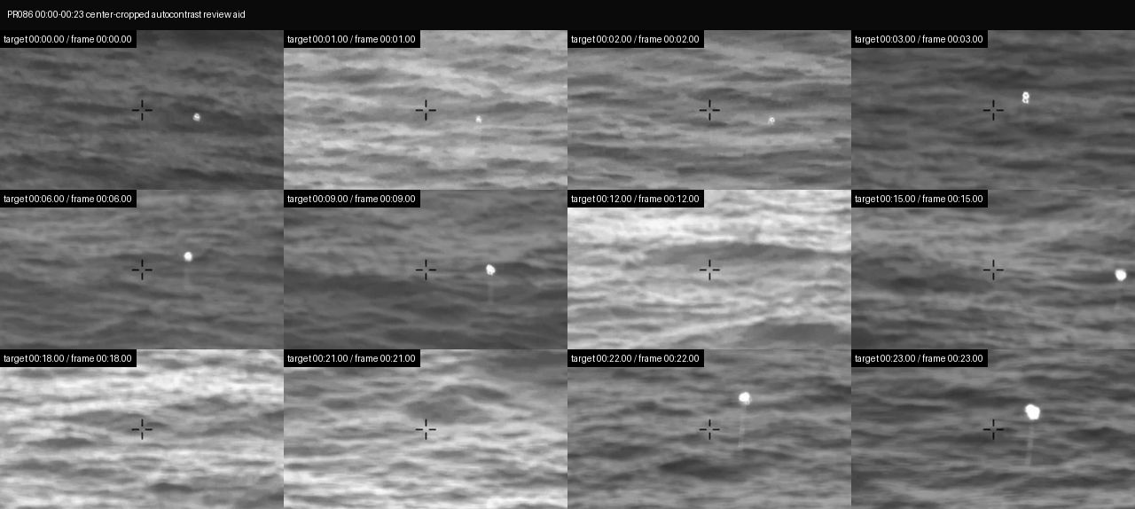
Across the 00:00 to 00:23 source-described tracking and contrast-mode windows, sampled review aids show a compact bright contrast area in several frames. It is usually offset from the reticle rather than cleanly centered on it, and its apparent shape changes from a point-like bright spot to a tiny cluster or short streak in some samples. The contrast-mode/autocontrast aid makes this feature easier to see against the water texture, but that same processing can exaggerate wave texture, sensor gain behavior, compression, sharpening, display scaling, or other artifacts. The source description supports cautious wording that the sensor is tracking an area of contrast; the public samples do not support an identity, size, range, altitude, speed, platform location, or cause.
The source labels 00:24 to 00:34 as No content. Sampled frames from that interval are not blank: they still show water-like imagery, reticle/display overlays, and black edge/bottom UI elements. The safest reading is that No content is source catalog wording for absence of the described contrast event, not an Open Sky claim that the public MP4 becomes empty or visually blank after 00:24.
The MP4 includes an AAC stereo audio stream, but a full decoded audio check returned zero signal in this source review (RMS 0.0, mean absolute sample 0.0, max absolute sample 0.0). No transcript or audible content is quoted here. The contact sheets below are derived review aids from the downloaded official MP4; they are not independent evidence and should not be used to infer cause, identity, speed, range, altitude, or event significance.
Source asset review
The individual official DVIDS/CloudFront MP4 was downloaded and inspected directly; the full Release 02 video ZIP was not used as a substitute. The direct media response returned 200, content-type: binary/octet-stream, accept-ranges: bytes, content-length: 17686298, last-modified: Fri, 22 May 2026 11:30:50 GMT, and ETag "5e705476c0d44208166d5ffdf8b1bdcb-3". A byte-range probe returned 206 with content-range: bytes 0-15/17686298; the first 16 bytes were MP4/M4V header bytes 0000001c667479704d34562000000001.
| Field | Source-review value |
|---|---|
| Direct media URL | https://d34w7g4gy10iej.cloudfront.net/video/2605/DOD_111720827/DOD_111720827.mp4 |
| Downloaded size | 17,686,298 bytes |
| SHA-256 | e9dacf0d1dc8c57056f7bf8dae95dfd71dac00535a51ec0c79190ea64ef5c748 |
| CRC32 of downloaded direct MP4 | 69fa849f |
| Container | QuickTime / MOV (mov,mp4,m4a,3gp,3g2,mj2) |
| Duration | 34.033333 seconds (DVIDS and manifest list 00:00:34) |
| Bit rate | 4,157,406 bps |
| Video stream | H.264, 1920x1080, 30 fps, 1,021 frames, yuv420p |
| Audio stream | AAC stereo, 48,000 Hz, about 33.993333 seconds, 1,595 stream frames |
| Audio signal check | 1,594 decoded audio frames / 3,263,360 sample values; RMS 0.0, mean absolute sample 0.0, max absolute sample 0.0; audio stream present but effectively silent in this decode |
| DVIDS filename / VIRIN | DOD_111720827 / 191201-D-D0360-9934 |
| DVIDS listed length | 00:00:34 |
The Release 02 remote video-ZIP central directory lists video_2605_DOD_111720827_DOD_111720827.mp4 as 17,681,116 bytes with CRC32 d376af92, stored uncompressed. That does not match the downloaded direct DVIDS MP4 size or CRC32. Until the ZIP entry is byte-compared against the direct DVIDS object, this should be treated as a source-custody/versioning lead, not as a substantive finding about the imagery.
Source custody and provenance
Primary public provenance for this page is the official WAR.GOV/PURSUE Release 02 landing page, the Release 02 manifest row, and the DVIDS page for video 1007797. The public DVIDS page resolves to https://www.dvidshub.net/video/1007797/dow-uap-pr086-uap-dec-2019-east-coast and exposes the direct media asset at https://d34w7g4gy10iej.cloudfront.net/video/2605/DOD_111720827/DOD_111720827.mp4.
The custody posture is intentionally bounded. The public release says many responsive materials lack a substantiated chain of custody. This row says the video was uploaded to a classified network in September 2020 and is likely derived from an infrared sensor aboard a U.S. military platform operating within the NORTHCOM area of responsibility in 2019. DVIDS adds a 12.01.2019 date taken, country/display location UNITED STATES / US, VIRIN 191201-D-D0360-9934, and filename DOD_111720827. Those fields are compatible at the broad catalog level with the manifest title's Dec 2019 (East Coast) wording, but they still need original sensor/platform records before Open Sky can assert precise platform identity, coordinates, range, target identity, or event reconstruction. This page preserves the official manifest/DVIDS provenance and downloaded-source inspection facts without converting the title, visible contrast feature, or AARO summary into an Open Sky finding.
Graph context
No exact Release 02 graph record was returned for this slug, title, or DVIDS ID during this run's read-only graph context check. That is not a source-access problem; it means this page is currently anchored to official manifest/DVIDS provenance while graph ingest for Release 02 catches up. Future title-related or dataset-wide graph hits should be treated as leads until their provenance links resolve back to this exact official asset.
Leads to check
- Byte-compare the direct DVIDS MP4 against the Release 02 video-ZIP entry because the direct-file size/CRC32 and ZIP central-directory size/CRC32 do not match.
- Review the
00:00to00:23window in continuous full-resolution motion, especially the contrast-mode changes from00:03to00:21, the compact bright contrast feature's offset from the reticle, and whether any apparent streaking or clustering persists between sampled frames. - Reconcile the manifest/source phrase
UAP from Dec 2019 (East Coast)with the body description's more cautiousarea of contrastlanguage; the title alone should not be used as an identity or performance finding. - Identify the camera/sensor type, display mode/polarity, contrast-mode switching behavior, masking/display effects, platform position, line of sight, range, and exact recording context.
- Run prosaic context checks before escalation: aircraft, drones, balloons, birds, debris, ordinary maritime or coastal traffic, wave glint or surface reflections, clouds/haze, atmospheric effects, sensor contrast/auto-gain behavior, parallax from platform motion, compression/display/redaction artifacts, East Coast/NORTHCOM air and maritime activity, weather, satellite/launch/reentry context, and any available military or civilian incident logs for 1 December 2019.
Limits
This is a compressed public MP4 derived from a classified-network upload, and the release-level source warning says many responsive materials lack a substantiated chain of custody. The public record does not provide the original file hash, original sensor metadata, platform identity, precise time of day, line of sight, range, altitude, coordinates, independent radar or optical tracks, air/maritime traffic correlation, weather correlation, or original witness/operator notes on this page. The source-described area of contrast is visible as a compact bright feature in sampled review aids, but its source, cause, distance, scale, and event significance remain unresolved from this asset alone. This page is a source-review draft and not a finding.
Sources
- WAR.GOV/PURSUE Release 02 landing page: https://www.war.gov/UFO/
- DVIDS video page: https://www.dvidshub.net/video/1007797
- DVIDS canonical video page: https://www.dvidshub.net/video/1007797/dow-uap-pr086-uap-dec-2019-east-coast
- DVIDS direct media asset: https://d34w7g4gy10iej.cloudfront.net/video/2605/DOD_111720827/DOD_111720827.mp4
- Release 02 document bundle: https://www.war.gov/medialink/ufo/052226/release_02/release_02_document_bundle.zip
- Release 02 video bundle: https://d34w7g4gy10iej.cloudfront.net/uap052226.zip
- Official Release 02 manifest row 146,
DOW-UAP-PR086, "UAP from Dec 2019 (East Coast)", release date5/22/26, agencyDepartment of War, kindVID.